
Thank you for supporting this site ❤️
Make a donation
Make a donation
Wolcottville topographic map
Click on the map to display elevation.
Thank you for supporting this site ❤️
Make a donation
Make a donation
About this map
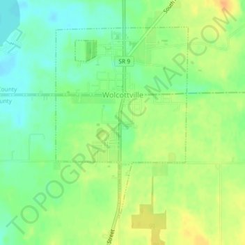
Name: Wolcottville topographic map, elevation, terrain.
Location: Wolcottville, Noble County, Indiana, United States (41.51232 -85.37652 41.53336 -85.35702)
Average elevation: 287 m
Minimum elevation: 270 m
Maximum elevation: 305 m
Thank you for supporting this site ❤️
Make a donation
Make a donation
Other topographic maps
Click on a map to view its topography, its elevation and its terrain.
Kendallville
United States > Indiana > Noble County > Kendallville > Kendallville
Average elevation: 304 m