
Thank you for supporting this site ❤️
Make a donation
Make a donation
Ontario topographic map
Click on the map to display elevation.
Thank you for supporting this site ❤️
Make a donation
Make a donation
About this map
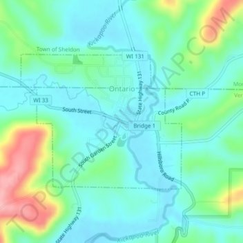
Name: Ontario topographic map, elevation, terrain.
Location: Ontario, Vernon County, Wisconsin, United States (43.71463 -90.60706 43.72961 -90.58236)
Average elevation: 294 m
Minimum elevation: 260 m
Maximum elevation: 395 m
Thank you for supporting this site ❤️
Make a donation
Make a donation
Other topographic maps
Click on a map to view its topography, its elevation and its terrain.
Wildcat Mountain State Park
United States > Wisconsin > Vernon County > Town of Whitestown
Average elevation: 310 m
Thank you for supporting this site ❤️
Make a donation
Make a donation
Wildcat Mountain State Park
United States > Wisconsin > Vernon County > Town of Whitestown
Average elevation: 310 m