
Thank you for supporting this site ❤️
Make a donation
Make a donation
Hudson topographic map
Click on the map to display elevation.
Thank you for supporting this site ❤️
Make a donation
Make a donation
About this map
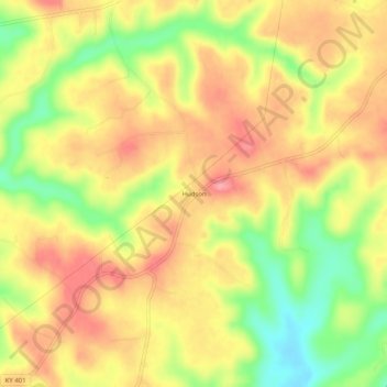
Name: Hudson topographic map, elevation, terrain.
Location: Hudson, Breckinridge County, Kentucky, 40015, United States (37.63117 -86.29664 37.67117 -86.25664)
Average elevation: 225 m
Minimum elevation: 167 m
Maximum elevation: 266 m
Thank you for supporting this site ❤️
Make a donation
Make a donation
Other topographic maps
Click on a map to view its topography, its elevation and its terrain.