
Thank you for supporting this site ❤️
Make a donation
Make a donation
Besut topographic map
Click on the map to display elevation.
Thank you for supporting this site ❤️
Make a donation
Make a donation
About this map
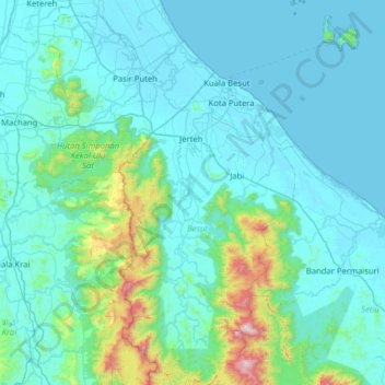
Name: Besut topographic map, elevation, terrain.
Location: Besut, Terengganu, Malaysia (5.33293 102.37847 5.96413 102.77294)
Average elevation: 153 m
Minimum elevation: -3 m
Maximum elevation: 1,487 m
Thank you for supporting this site ❤️
Make a donation
Make a donation
Other topographic maps
Click on a map to view its topography, its elevation and its terrain.