
La Rivière topographic map
Interactive map
Click on the map to display elevation.
About this map
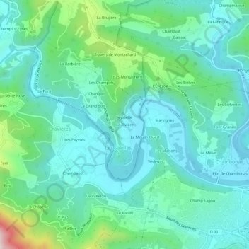
Name: La Rivière topographic map, elevation, terrain.
Average elevation: 257 m
Minimum elevation: 136 m
Maximum elevation: 717 m
Other topographic maps
Click on a map to view its topography, its elevation and its terrain.
La Rivière
France > Auvergne-Rhône-Alpes > La Rivière
La Rivière, Tournon-sur-Rhône, Ardèche, Auvergne-Rhône-Alpes, France métropolitaine, 07370, France
Average elevation: 232 m