
Make a donation
Aspet topographic map
Click on the map to display elevation.
Make a donation
Aspet
Located in the middle of the Pyrenees mountain chain, within the ancient region of Comminges, Aspet sits 15 km south to Saint-Gaudens and at the foot of the Cagire (1,912 metres (6,273 ft) in Altitude).
Make a donation
About this map
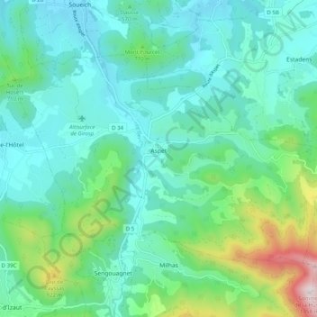
Name: Aspet topographic map, elevation, terrain.
Average elevation: 583 m
Minimum elevation: 385 m
Maximum elevation: 1,340 m
Make a donation
Other topographic maps
Click on a map to view its topography, its elevation and its terrain.
Make a donation
Toulouse
France > Occitania > Haute-Garonne > Toulouse
The first half of the 14th century was a prosperous period, despite the dismemberment in 1317 of the very large bishopric of Toulouse (which lost two thirds of its area and a large part of its income, a loss only partially compensated by its elevation to the rank of archbishopric), and the episode of the…
Average elevation: 173 m