
Thank you for supporting this site ❤️
Make a donation
Make a donation
Neah Bay topographic map
Click on the map to display elevation.
Thank you for supporting this site ❤️
Make a donation
Make a donation
About this map
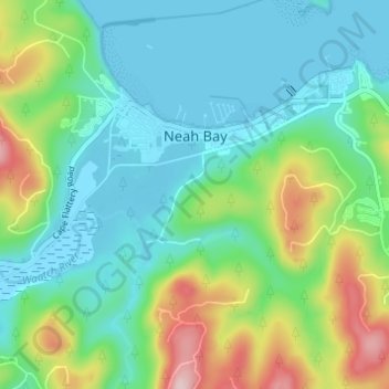
Name: Neah Bay topographic map, elevation, terrain.
Location: Neah Bay, Clallam County, Washington, 98357, United States (48.33916 -124.64734 48.37919 -124.58623)
Average elevation: 72 m
Minimum elevation: -4 m
Maximum elevation: 267 m
Thank you for supporting this site ❤️
Make a donation
Make a donation
Other topographic maps
Click on a map to view its topography, its elevation and its terrain.
Olympic Peninsula Gardens
United States > Washington > Clallam County > Sequim
Average elevation: 45 m
Thank you for supporting this site ❤️
Make a donation
Make a donation
Thank you for supporting this site ❤️
Make a donation
Make a donation
Thank you for supporting this site ❤️
Make a donation
Make a donation