
Thank you for supporting this site ❤️
Make a donation
Make a donation
Le Petit Bois topographic map
Click on the map to display elevation.
Thank you for supporting this site ❤️
Make a donation
Make a donation
About this map
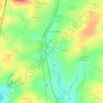
Name: Le Petit Bois topographic map, elevation, terrain.
Average elevation: 56 m
Minimum elevation: 22 m
Maximum elevation: 96 m
Thank you for supporting this site ❤️
Make a donation
Make a donation
Other topographic maps
Click on a map to view its topography, its elevation and its terrain.
Le Pouzat
France > Nouvelle-Aquitaine > Charente-Maritime > Essouvert > Le Pouzat
Average elevation: 75 m