
Thank you for supporting this site ❤️
Make a donation
Make a donation
Bugerru/Buggerru topographic map
Click on the map to display elevation.
Thank you for supporting this site ❤️
Make a donation
Make a donation
About this map
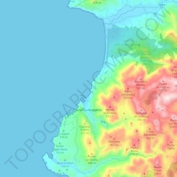
Name: Bugerru/Buggerru topographic map, elevation, terrain.
Location: Bugerru/Buggerru, Sulcis Iglesiente, Sardinia, 09010, Italy (39.36671 8.37825 39.44855 8.48911)
Average elevation: 139 m
Minimum elevation: -1 m
Maximum elevation: 646 m
Thank you for supporting this site ❤️
Make a donation
Make a donation
Other topographic maps
Click on a map to view its topography, its elevation and its terrain.
Thank you for supporting this site ❤️
Make a donation
Make a donation
Thank you for supporting this site ❤️
Make a donation
Make a donation
Thank you for supporting this site ❤️
Make a donation
Make a donation
Monte Maria
Italy > Sardinia > Cagliari > Quartu Sant'Aleni/Quartu Sant'Elena
Average elevation: 504 m
Spiaggia della Balena
Italy > Sardinia > Aristanis/Oristano > Cùllieri/Cuglieri > Torre del Pozzo
Average elevation: 31 m
Thank you for supporting this site ❤️
Make a donation
Make a donation
Thank you for supporting this site ❤️
Make a donation
Make a donation