
Järva stadsdelsområde topographic map
Interactive map
Click on the map to display elevation.
About this map
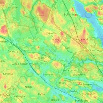
Name: Järva stadsdelsområde topographic map, elevation, terrain.
Average elevation: 23 m
Minimum elevation: -5 m
Maximum elevation: 59 m
Other topographic maps
Click on a map to view its topography, its elevation and its terrain.
Luna
Suède > Comté de Stockholm > Stockholm
Luna, Gamla stan, Södermalms stadsdelsområde, Stockholm, Stockholms kommun, Comté de Stockholm, 111 30, Suède
Average elevation: 19 m
Humboldt
Suède > Comté de Stockholm > Stockholm
Humboldt, Hagastaden, Vasastaden, Norra Innerstaden, Stockholm, Solna kommun, Comté de Stockholm, 113 66, Suède
Average elevation: 21 m