
West Bromwich topographic map
Interactive map
Click on the map to display elevation.
About this map
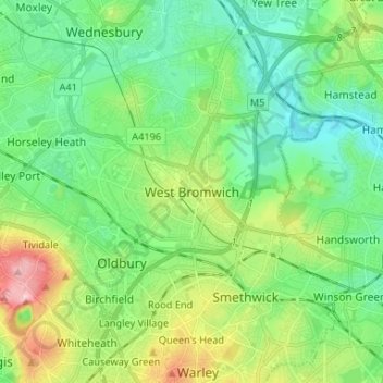
Name: West Bromwich topographic map, elevation, terrain.
Average elevation: 149 m
Minimum elevation: 98 m
Maximum elevation: 270 m
Other topographic maps
Click on a map to view its topography, its elevation and its terrain.
Oldbury
United Kingdom > England > Sandwell
Oldbury, Sandwell, West Midlands Combined Authority, England, B69 2AJ, United Kingdom
Average elevation: 161 m
Turner's Portway
United Kingdom > England > Sandwell > Rowley Village > Turner's Portway
Turner's Portway, Rowley Village, Sandwell, West Midlands Combined Authority, West Midlands, England, B65 9DE, United Kingdom
Average elevation: 174 m
Sandwell
United Kingdom > England > Sandwell
Sandwell, West Midlands Combined Authority, West Midlands, England, United Kingdom
Average elevation: 152 m