
Oberaarhorn topographic map
Interactive map
Click on the map to display elevation.
About this map
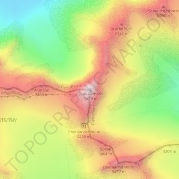
Name: Oberaarhorn topographic map, elevation, terrain.
Average elevation: 3,104 m
Minimum elevation: 2,566 m
Maximum elevation: 3,620 m
Other topographic maps
Click on a map to view its topography, its elevation and its terrain.
Hienderstock
Hienderstock, Guttannen, Verwaltungskreis Interlaken-Oberhasli, Verwaltungsregion Oberland, Berna, 3864, Svizzera
Average elevation: 2,813 m
Ewigschneehorn
Ewigschneehorn, Guttannen, Verwaltungskreis Interlaken-Oberhasli, Verwaltungsregion Oberland, Berna, 3864, Svizzera
Average elevation: 2,866 m
Lauteraarhorn
Lauteraarhorn, Guttannen, Verwaltungskreis Interlaken-Oberhasli, Verwaltungsregion Oberland, Berna, 3864, Svizzera
Average elevation: 3,313 m
Mährenhorn
Mährenhorn, Guttannen, Verwaltungskreis Interlaken-Oberhasli, Verwaltungsregion Oberland, Berna, 3864, Svizzera
Average elevation: 2,337 m
Bächlistock
Bächlistock, Guttannen, Verwaltungskreis Interlaken-Oberhasli, Verwaltungsregion Oberland, Berna, 3864, Svizzera
Average elevation: 2,771 m