
Thank you for supporting this site ❤️
Make a donation
Make a donation
Keavy topographic map
Click on the map to display elevation.
Thank you for supporting this site ❤️
Make a donation
Make a donation
About this map
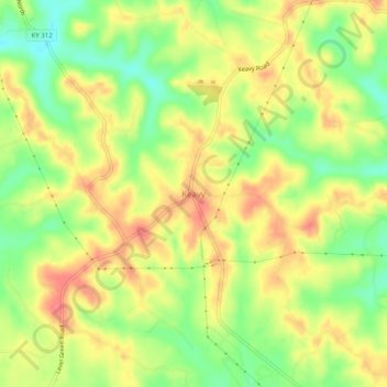
Name: Keavy topographic map, elevation, terrain.
Location: Keavy, Laurel County, Kentucky, 40737, United States (36.98370 -84.18104 37.02370 -84.14104)
Average elevation: 363 m
Minimum elevation: 327 m
Maximum elevation: 393 m
Thank you for supporting this site ❤️
Make a donation
Make a donation
Other topographic maps
Click on a map to view its topography, its elevation and its terrain.
London
United States > Kentucky > Laurel County
London is located in central Laurel County at 37°7′39″N 84°5′3″W / 37.12750°N 84.08417°W / 37.12750; -84.08417 (37.127504, -84.084181) and at an elevation of 1,240 feet (380 m).
Average elevation: 370 m
Thank you for supporting this site ❤️
Make a donation
Make a donation