
Mandi topographic map
Interactive map
Click on the map to display elevation.
About this map
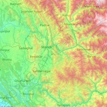
Name: Mandi topographic map, elevation, terrain.
Location: Mandi, Himachal Pradesh, Indien (31.23263 76.60605 32.07604 77.37726)
Average elevation: 1,609 m
Minimum elevation: 303 m
Maximum elevation: 5,221 m
Other topographic maps
Click on a map to view its topography, its elevation and its terrain.
Padron
Indien > Himachal Pradesh > Chamba
Padron, Chamba, Chamba District, Himachal Pradesh, Indien
Average elevation: 1,817 m
Shimla
Indien > Himachal Pradesh > Shimla
Shimla, Shimla (urban), Shimla, Himachal Pradesh, 171001, Indien
Average elevation: 1,557 m