
Thank you for supporting this site ❤️
Make a donation
Make a donation
Port d'Andratx topographic map
Click on the map to display elevation.
Thank you for supporting this site ❤️
Make a donation
Make a donation
About this map
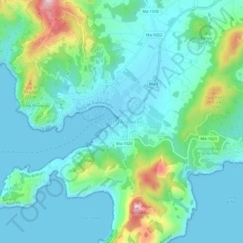
Name: Port d'Andratx topographic map, elevation, terrain.
Average elevation: 63 m
Minimum elevation: 0 m
Maximum elevation: 298 m
Thank you for supporting this site ❤️
Make a donation
Make a donation
Other topographic maps
Click on a map to view its topography, its elevation and its terrain.
Cala Llamp
España > Islas Baleares > Sierra de Tramontana > Andrach > Port d'Andratx
Average elevation: 54 m