
Make a donation
Chetwynd topographic map
Click on the map to display elevation.
Make a donation
Chetwynd
Carved out of an ancient floodplain, the small terrace upon which Chetwynd is situated lies in the northern foothills of the Rocky Mountains. Once used as a grazing spot by nomadic Aboriginals, the terrace was farmed by settlers until it was developed into a town. Two types of soil—namely, the Widmark and Centurion Series—comprise the terrace's surface. The Widmark Series—a moderately well-drained degraded loamy, woody, silty, and clay-like soil—lies north of Highway 97. Meanwhile, the Centurion Series—which lies south of the highway—is a poorly drained soil with a dark-brown peaty surface material consisting of decomposed leaves and mosses. These soils, also limited by topography and stoniness, are generally used for forage and pasture.
Make a donation
About this map
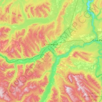
Name: Chetwynd topographic map, elevation, terrain.
Average elevation: 910 m
Minimum elevation: 469 m
Maximum elevation: 1,660 m
Make a donation