
Molln topographic map
Interactive map
Click on the map to display elevation.
About this map
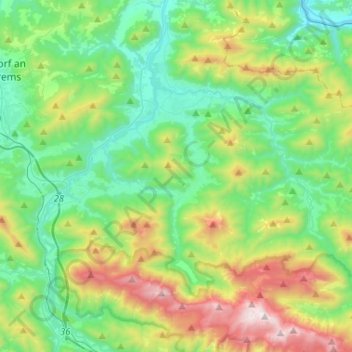
Name: Molln topographic map, elevation, terrain.
Location: Molln, Bezirk Kirchdorf, Oberösterreich, 4591, Österreich (47.78230 14.15533 47.92266 14.41534)
Average elevation: 791 m
Minimum elevation: 331 m
Maximum elevation: 1,945 m
Other topographic maps
Click on a map to view its topography, its elevation and its terrain.
Hinterstoder
Österreich > Oberösterreich > Bezirk Kirchdorf
Hinterstoder, Bezirk Kirchdorf, Oberösterreich, 4573, Österreich
Average elevation: 1,283 m
Kaibling
Österreich > Oberösterreich > Bezirk Kirchdorf > Pettenbach
Kaibling, Pettenbach, Bezirk Kirchdorf, Oberösterreich, 4643, Österreich
Average elevation: 586 m
Penzendorf
Österreich > Oberösterreich > Bezirk Kirchdorf > Wartberg an der Krems
Penzendorf, Wartberg an der Krems, Bezirk Kirchdorf, Oberösterreich, 4552, Österreich
Average elevation: 454 m
Rosenau am Hengstpaß
Österreich > Oberösterreich > Bezirk Kirchdorf > Rosenau am Hengstpaß
Rosenau am Hengstpaß, Bezirk Kirchdorf, Oberösterreich, 4581, Österreich
Average elevation: 1,043 m
Schweizersberg
Österreich > Oberösterreich > Bezirk Kirchdorf > Roßleithen
Schweizersberg, Roßleithen, Bezirk Kirchdorf, Oberösterreich, 4575, Österreich
Average elevation: 668 m
Spital am Pyhrn
Österreich > Oberösterreich > Bezirk Kirchdorf
Spital am Pyhrn, Bezirk Kirchdorf, Oberösterreich, 4582, Österreich
Average elevation: 1,106 m
Ried im Traunkreis
Österreich > Oberösterreich > Bezirk Kirchdorf > Ried im Traunkreis
Ried im Traunkreis, Bezirk Kirchdorf, Oberösterreich, 4551, Österreich
Average elevation: 439 m
Kirchdorf an der Krems
Österreich > Oberösterreich > Bezirk Kirchdorf
Kirchdorf an der Krems, Bezirk Kirchdorf, Oberösterreich, 4560, Österreich
Average elevation: 475 m