
Make a donation
Kavaratti topographic map
Click on the map to display elevation.
Make a donation
Kavaratti
The island of Kavaratti lies 360 km (190 nmi) off the coast of the state of Kerala at 10°34′N 72°38′E / 10.57°N 72.64°E / 10.57; 72.64. It has an average elevation of 0 metres (0 feet).
Make a donation
About this map
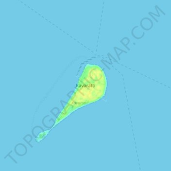
Name: Kavaratti topographic map, elevation, terrain.
Location: Kavaratti, Lakshadweep, 262240, India (10.52722 72.59946 10.60722 72.67946)
Average elevation: 0 m
Minimum elevation: 0 m
Maximum elevation: 17 m
Make a donation
Other topographic maps
Click on a map to view its topography, its elevation and its terrain.
Kavaratti Island
India > Lakshadweep > Kavaratti > Kavaratti
The island of Kavaratti lies 360 km (190 nmi) off the coast of the state of Kerala at 10°34′N 72°38′E / 10.57°N 72.64°E / 10.57; 72.64. It has an average elevation of 0 metres (0 feet).
Average elevation: 2 m