
Thank you for supporting this site ❤️
Make a donation
Make a donation
Missy topographic map
Click on the map to display elevation.
Thank you for supporting this site ❤️
Make a donation
Make a donation
About this map
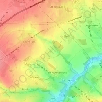
Name: Missy topographic map, elevation, terrain.
Average elevation: 102 m
Minimum elevation: 48 m
Maximum elevation: 134 m
Thank you for supporting this site ❤️
Make a donation
Make a donation
Other topographic maps
Click on a map to view its topography, its elevation and its terrain.
La Cour d'Arry
France > Normandie > Calvados > Val d'Arry > Le Locheur > La Cour d'Arry
Average elevation: 94 m
Thank you for supporting this site ❤️
Make a donation
Make a donation