
Thank you for supporting this site ❤️
Make a donation
Make a donation
Roßdorf topographic map
Click on the map to display elevation.
Thank you for supporting this site ❤️
Make a donation
Make a donation
About this map
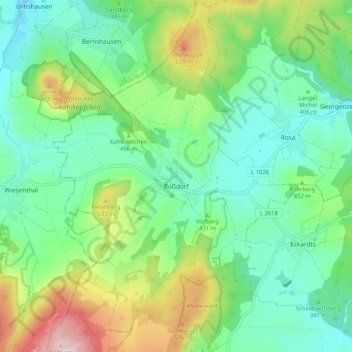
Name: Roßdorf topographic map, elevation, terrain.
Average elevation: 436 m
Minimum elevation: 322 m
Maximum elevation: 707 m
Thank you for supporting this site ❤️
Make a donation
Make a donation
Other topographic maps
Click on a map to view its topography, its elevation and its terrain.
Rotterode
Germany > Thuringia > Landkreis Schmalkalden-Meiningen > Steinbach-Hallenberg
Average elevation: 570 m