
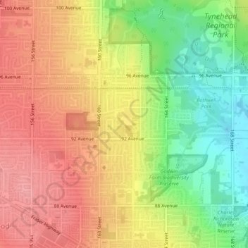
Serpentine Heights Park topographic map
Interactive map
Click on the map to display elevation.
About this map
Name: Serpentine Heights Park topographic map, elevation, terrain.
Average elevation: 59 m
Minimum elevation: 3 m
Maximum elevation: 102 m
Other topographic maps
Click on a map to view its topography, its elevation and its terrain.
Surrey
Canada > British Columbia > Metro Vancouver Regional District > Surrey
Surrey, Metro Vancouver Regional District, British Columbia, V3T 1V8, Canada
Average elevation: 65 m
Crescent Beach
Canada > British Columbia > Metro Vancouver Regional District > Surrey
Crescent Beach, South Surrey, Surrey, Metro Vancouver Regional District, British Columbia, Canada
Average elevation: 22 m
Cloverdale
Canada > British Columbia > Metro Vancouver Regional District > Surrey
Cloverdale, Surrey, Metro Vancouver Regional District, British Columbia, Canada
Average elevation: 24 m
Newton
Canada > British Columbia > Metro Vancouver Regional District > Surrey
Newton, Surrey, Metro Vancouver Regional District, British Columbia, Canada
Average elevation: 48 m
Walnut Park
Canada > British Columbia > Metro Vancouver Regional District > Surrey
Walnut Park, Fleetwood, Surrey, Metro Vancouver Regional District, British Columbia, Canada
Average elevation: 49 m
South Surrey
Canada > British Columbia > Metro Vancouver Regional District > Surrey
South Surrey, Surrey, Metro Vancouver Regional District, British Columbia, Canada
Average elevation: 28 m
Tynehead Regional Park
Canada > British Columbia > Metro Vancouver Regional District > Surrey
Tynehead Regional Park, Guildford, Surrey, Metro Vancouver Regional District, British Columbia, Canada
Average elevation: 45 m
Guildford
Canada > British Columbia > Metro Vancouver Regional District > Surrey
Guildford, Surrey, Metro Vancouver Regional District, British Columbia, Canada
Average elevation: 46 m
Cottonwood Park
Canada > British Columbia > Metro Vancouver Regional District > Surrey
Cottonwood Park, Fleetwood, Surrey, Metro Vancouver Regional District, British Columbia, Canada
Average elevation: 37 m