
Kent County topographic map
Interactive map
Click on the map to display elevation.
About this map
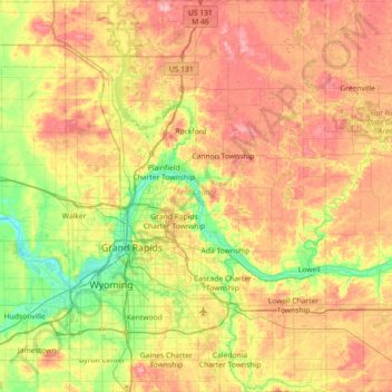
Name: Kent County topographic map, elevation, terrain.
Location: Kent County, Michigan, États-Unis (42.76807 -85.79061 43.29431 -85.30958)
Average elevation: 240 m
Minimum elevation: 177 m
Maximum elevation: 318 m
Other topographic maps
Click on a map to view its topography, its elevation and its terrain.
Grosse Ile
États-Unis > Michigan > Grosse Ile
Grosse Ile, Grosse Ile Township, Wayne County, Michigan, 48138, États-Unis
Average elevation: 178 m
Au Sable River
Au Sable River, Au Sable Township, Iosco County, Michigan, États-Unis
Average elevation: 178 m
Gun Lake
Gun Lake, Hastings Point Road, Yankee Springs Township, Barry County, Michigan, 49333, États-Unis
Average elevation: 234 m
Ramsey Lake
Ramsey Lake, Dd Road, Nahma Township, Delta County, Michigan, États-Unis
Average elevation: 227 m
Anchor Bay
États-Unis > Michigan > New Baltimore
Anchor Bay, Taylor Street, New Baltimore, Macomb County, Michigan, 48047, États-Unis
Average elevation: 173 m