
Thank you for supporting this site ❤️
Make a donation
Make a donation
Pailhe topographic map
Click on the map to display elevation.
Thank you for supporting this site ❤️
Make a donation
Make a donation
About this map
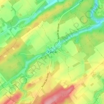
Name: Pailhe topographic map, elevation, terrain.
Location: Pailhe, Clavier, Huy, Liège, Wallonie, 4560, Belgique (50.40250 5.23862 50.44250 5.27862)
Average elevation: 240 m
Minimum elevation: 187 m
Maximum elevation: 305 m
Thank you for supporting this site ❤️
Make a donation
Make a donation
Other topographic maps
Click on a map to view its topography, its elevation and its terrain.
Thank you for supporting this site ❤️
Make a donation
Make a donation