
Thank you for supporting this site ❤️
Make a donation
Make a donation
Abergynolwyn topographic map
Click on the map to display elevation.
Thank you for supporting this site ❤️
Make a donation
Make a donation
About this map
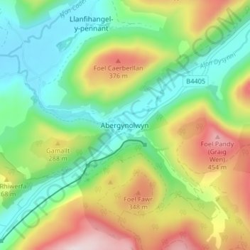
Name: Abergynolwyn topographic map, elevation, terrain.
Location: Abergynolwyn, Gwynedd, Wales, LL36 9YH, United Kingdom (52.62506 -3.97610 52.66506 -3.93610)
Average elevation: 187 m
Minimum elevation: 11 m
Maximum elevation: 484 m
Thank you for supporting this site ❤️
Make a donation
Make a donation
Other topographic maps
Click on a map to view its topography, its elevation and its terrain.