
Pedraído topographic map
Interactive map
Click on the map to display elevation.
About this map
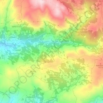
Name: Pedraído topographic map, elevation, terrain.
Location: Pedraído, Fafe, Braga, Portugal (41.49130 -8.13824 41.53130 -8.09824)
Average elevation: 646 m
Minimum elevation: 476 m
Maximum elevation: 826 m
Other topographic maps
Click on a map to view its topography, its elevation and its terrain.
Monte e Queimadela
Monte e Queimadela, Fafe, Braga, Portugal
Average elevation: 557 m
Queimadela
Queimadela, Fafe, Braga, 4820-511, Portugal
Average elevation: 583 m
Agrela e Serafão
Agrela e Serafão, Fafe, Braga, Portugal
Average elevation: 325 m
Arões (São Romão)
Arões (São Romão), Fafe, Braga, Portugal
Average elevation: 381 m
Vila Pouca
Vila Pouca, Moreira do Rei e Várzea Cova, Fafe, Braga, 4820-840, Portugal
Average elevation: 642 m