
Thank you for supporting this site ❤️
Make a donation
Make a donation
Parkersburg topographic map
Click on the map to display elevation.
Thank you for supporting this site ❤️
Make a donation
Make a donation
About this map
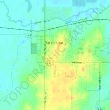
Name: Parkersburg topographic map, elevation, terrain.
Location: Parkersburg, Butler County, Iowa, United States (42.56304 -92.79555 42.58152 -92.75646)
Average elevation: 295 m
Minimum elevation: 282 m
Maximum elevation: 317 m
Thank you for supporting this site ❤️
Make a donation
Make a donation
Other topographic maps
Click on a map to view its topography, its elevation and its terrain.