
Make a donation
Himalayas topographic map
Click on the map to display elevation.
Make a donation
Himalayas
The Himalayas, or Himalaya (/ˌhɪməˈleɪ.ə, hɪˈmɑːləjə/ HIM-ə-LAY-ə, hih-MAH-lə-yə), is a mountain range in Asia, separating the plains of the Indian subcontinent from the Tibetan Plateau. The range has some of the Earth's highest peaks, including the highest, Mount Everest. More than 100 peaks exceeding elevations of 7,200 m (23,600 ft) above sea level lie in the Himalayas.
Make a donation
About this map
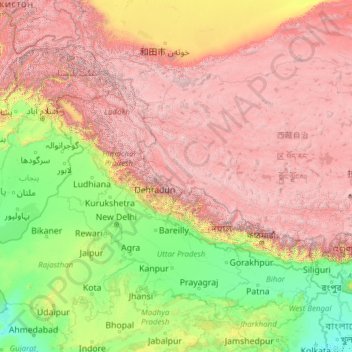
Name: Himalayas topographic map, elevation, terrain.
Location: Himalayas, China (26.86330 75.08054 34.94000 94.72410)
Average elevation: 2,385 m
Minimum elevation: -2 m
Maximum elevation: 8,096 m
Make a donation
Other topographic maps
Click on a map to view its topography, its elevation and its terrain.
Yunnan
Yunnan is situated in a mountainous area, with high elevations in the northwest and low elevations in the southeast. Most of the population lives in the eastern part of the province. In the west, the altitude can vary from the mountain peaks to river valleys by as much as 3,000 m (9,800 ft). Yunnan is rich in…
Average elevation: 1,713 m
Make a donation
Make a donation
Chongqing
The central urban area of Chongqing, or Chongqing proper, is a city of unique features. Built on mountains and partially surrounded by the Yangtze and Jialing rivers, it is known as a "mountain city" and a "city on rivers". The night scene of the city is very illuminated, with millions of lights and their…
Average elevation: 318 m
Kunming
Kunming (/kʊnˈmɪŋ/;[3] Chinese: 昆明; pinyin: Kūnmíng), also known as Yunnan-Fu, is the capital and largest city of Yunnan province, China.[4] It is the political, economic, communications and cultural centre of the province as well as the seat of the provincial government. The headquarters of many of…
Average elevation: 1,996 m
Make a donation
Beijing
Beijing is situated at the northern tip of the roughly triangular North China Plain, which opens to the south and east of the city. Mountains to the north, northwest and west shield the city and northern China's agricultural heartland from the encroaching desert steppes. The northwestern part of the…
Average elevation: 460 m
Make a donation
Make a donation
Make a donation
Make a donation
Mount Kailash
China > Tibet > Purang County > Darchen
Mount Kailash (also Kailasa; Kangrinboqê or Gang Rinpoche; Tibetan: གངས་རིན་པོ་ཆེ; simplified Chinese: 冈仁波齐峰; traditional Chinese: 岡仁波齊峰; Sanskrit: कैलास, IAST: Kailāsa), is a mountain in the Ngari Prefecture, Tibet Autonomous Region of China. It has an…
Average elevation: 5,756 m
Make a donation
Shanghai
The golden age of Shanghai began with its elevation to municipality on 7 July 1927. This new Chinese municipality covered an area of 494.69 km2 (191.0 sq mi), including the modern-day districts of Baoshan, Yangpu, Zhabei, Nanshi, and Pudong, but excluded the foreign concessions territories. Headed by a Chinese…
Average elevation: 5 m
Shahekou District
The district's western portion is generally higher in elevation, and has seven notable peaks. The district has 8 kilometres (5.0 mi) of coastline.
Average elevation: 40 m
Hong Kong
Hong Kong has a humid subtropical climate (Köppen Cwa), characteristic of southern China, despite being located south of the Tropic of Cancer. Summers are long, hot and humid, with occasional showers and thunderstorms and warm air from the southwest. The humid nature of Hong Kong exacerbates the warmth of…
Average elevation: 47 m
Make a donation
Hong Kong
Hong Kong has a humid subtropical climate (Köppen Cwa), characteristic of southern China, despite being located south of the Tropic of Cancer. Summer is hot and humid, with occasional showers and thunderstorms and warm air from the southwest. Typhoons occur most often then, sometimes resulting in floods or…
Average elevation: 47 m
Xinjiang
A semiarid or desert climate (Köppen BSk or BWk, respectively) prevails in Xinjiang. The entire region has great seasonal differences in temperature with cold winters. The Turpan Depression recorded the hottest temperatures nationwide in summer, with air temperatures easily exceeding 40 °C (104 °F). Winter…
Average elevation: 2,188 m
Sichuan
Due to great differences in terrain, the climate of the province is highly variable. In general, it has strong monsoonal influences, with rainfall heavily concentrated in the summer. Under the Köppen climate classification, the Sichuan Basin (including Chengdu) in the eastern half of the province experiences…
Average elevation: 2,522 m
Make a donation
Shiyan
The far northern and southern reaches of Shiyan are the highest in elevation, while the geographic center of the city has a relatively low elevation. The highest point in Shiyan is Congping in Zhuxi County, at 2,740.2 metres (8,990 ft) above sea level, while the lowest point, Panjiayan in Danjiangkou, is 87…
Average elevation: 422 m
Make a donation
Make a donation
Xi'an
China > Shaanxi > Weiyang District > Xi'an
Xi'an lies on the Guanzhong Plain in the south-central part of Shaanxi province, on a flood plain created by the eight surrounding rivers and streams. The city has an average elevation of 400 metres (1,312 ft) above sea level and an annual precipitation of 553 mm (21.8 in). The urban area of Xi'an is located…
Average elevation: 412 m
Chongqing
The central urban area of Chongqing, or Chongqing proper, is a city of unique features. Built on mountains and partially surrounded by the Yangtze and Jialing rivers, it is known as a "mountain city" and a "city on rivers". The night scene of the city is very illuminated, with millions of lights and their…
Average elevation: 754 m
Make a donation
Fujian
The province is mostly mountainous and is traditionally said to be "eight parts mountain, one part water, and one part farmland" (八山一水一分田). The northwest is higher in altitude, with the Wuyi Mountains forming the border between Fujian and Jiangxi. It is the most forested provincial-level…
Average elevation: 302 m
Make a donation
Shangri-La
Shangri-La has either a dry-winter, warm-summer humid continental climate (Köppen climate classification: Dwb) using the 0 °C (32 °F) isotherm, or a dry-winter subtropical highland climate (Köppen climate classification: Cwb) using the −3 °C (26.6 °F) isotherm, both of which are unusually cool by…
Average elevation: 3,342 m
Make a donation
Shanghai
The golden age of Shanghai began with its elevation to municipality after it was separated from Jiangsu on 7 July 1927. This new Chinese municipality covered an area of 494.69 km2 (191.0 sq mi), including the modern-day districts of Baoshan, Yangpu, Zhabei, Nanshi, and Pudong, but excluded the foreign…
Average elevation: 12 m
Beijing
Beijing is situated at the northern tip of the roughly triangular North China Plain, which opens to the south and east of the city. Mountains to the north, northwest and west shield the city and northern China's agricultural heartland from the encroaching desert steppes. The northwestern part of the…
Average elevation: 460 m
Make a donation
Make a donation
Make a donation
Nang County
Nang is located in the south-west of Nyingtri, at the middle and lower reaches of the Yarlung Tsangpo River. The county seat of Nang County is situated in a region resembling an elephant's trunk, leading to the metaphorical designation of this area as "Nang" which translates to elephant. The average altitude…
Average elevation: 4,608 m
Make a donation
Aksai Chin
Because of its 5,000 metres (16,000 ft) elevation, the desolation of Aksai Chin meant that it had no human importance other than as an ancient trade route, which provided a temporary pass during summer for caravans of yaks between Xinjiang and Tibet. For military campaigns, the region held great importance, as…
Average elevation: 5,201 m
Make a donation
Make a donation
Make a donation
Make a donation
Barköl Kazakh Autonomous County
Barkol Kazakh Autonomous County spans a total area of 38,400 square kilometres (14,800 mi2), including 25,500 square kilometres (9,800 mi2) of mountains and the Gobi Desert, accounting for 66% of the total area of the autonomous county. The terrain is high in the southeast and low in the northwest, with an…
Average elevation: 1,436 m
Qaidam Basin
China > Qinghai > Da Qaidam Administrative Zone > Qaidam
Orographically, the Qaidam Basin is a comparatively low area in the northeastern part of the Tibetan Plateau. With an elevation of around 3,000 m (10,000 ft), Qaidam forms a kind of shelf between Tibet to the south (around 4,300 m or 14,000 ft) and Gansu to the north (around 1,100 m or 3,500 ft). A low water…
Average elevation: 2,742 m
Make a donation
Make a donation