
Thank you for supporting this site ❤️
Make a donation
Make a donation
Achill Island topographic map
Click on the map to display elevation.
Thank you for supporting this site ❤️
Make a donation
Make a donation
About this map
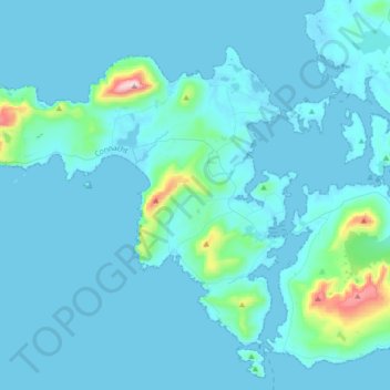
Name: Achill Island topographic map, elevation, terrain.
Location: Achill Island, County Mayo, Connacht, F28 X018, Ireland (53.87408 -10.25877 54.03020 -9.91432)
Average elevation: 42 m
Minimum elevation: -2 m
Maximum elevation: 659 m
Thank you for supporting this site ❤️
Make a donation
Make a donation
Other topographic maps
Click on a map to view its topography, its elevation and its terrain.