
Thank you for supporting this site ❤️
Make a donation
Make a donation
Marigot topographic map
Click on the map to display elevation.
Thank you for supporting this site ❤️
Make a donation
Make a donation
About this map
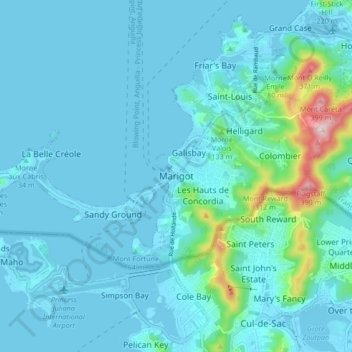
Name: Marigot topographic map, elevation, terrain.
Location: Marigot, Saint Martin (France), Saint Martin, 97150, France (18.02685 -63.12489 18.10685 -63.04489)
Average elevation: 44 m
Minimum elevation: -2 m
Maximum elevation: 414 m
Thank you for supporting this site ❤️
Make a donation
Make a donation
Other topographic maps
Click on a map to view its topography, its elevation and its terrain.