
Sioux County topographic map
Interactive map
Click on the map to display elevation.
About this map
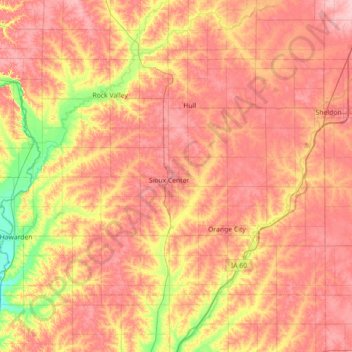
Name: Sioux County topographic map, elevation, terrain.
Location: Sioux County, Iowa, United States (42.90908 -96.57149 43.26003 -95.85839)
Average elevation: 418 m
Minimum elevation: 351 m
Maximum elevation: 466 m
Other topographic maps
Click on a map to view its topography, its elevation and its terrain.
Chatsworth
United States > Iowa > Sioux County > Chatsworth > Chatsworth
Chatsworth, Sioux County, Iowa, 51011, United States
Average elevation: 359 m
Chatsworth
United States > Iowa > Sioux County
Chatsworth, Sioux County, Iowa, 51011, United States
Average elevation: 357 m
Hawarden
United States > Iowa > Sioux County
Hawarden, Sioux County, Iowa, United States
Average elevation: 365 m