
Thank you for supporting this site ❤️
Make a donation
Make a donation
Nieuw Namen topographic map
Click on the map to display elevation.
Thank you for supporting this site ❤️
Make a donation
Make a donation
About this map
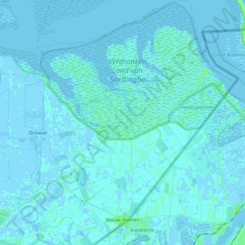
Name: Nieuw Namen topographic map, elevation, terrain.
Location: Nieuw Namen, Hulst, Zeeland, Nederland (51.28235 4.10937 51.38756 4.23681)
Average elevation: 1 m
Minimum elevation: -4 m
Maximum elevation: 9 m
Thank you for supporting this site ❤️
Make a donation
Make a donation
Other topographic maps
Click on a map to view its topography, its elevation and its terrain.
Verdronken Land van Saeftinghe
Nederland > Zeeland > Nieuw Namen
Het verschil tussen hoog- en laagwater bedraagt ter hoogte van het verdronken land gemiddeld 4,80 meter, maar bij springtij kan dat oplopen tot ruim zeven meter. Het getijverschil is het grootste van heel Nederland. Het verschil met de Westerscheldemonding is aanzienlijk: in Het Zwin bedraagt het gemiddelde…
Average elevation: 1 m