
Make a donation
Kunming topographic map
Click on the map to display elevation.
Make a donation
Kunming
Kunming is at an altitude of 1,900 metres (6,234 feet) above sea level and a latitude just north of the Tropic of Cancer, and is situated in the middle of the Yunnan–Guizhou Plateau. Kunming is the fourth most populous city in Western China, after Chongqing, Chengdu, and Xi'an, and the third most populous city in Southwestern China after Chongqing and Chengdu. As of the 2020 census, Kunming had a total population of 8,460,088 inhabitants, of whom 5,604,310 lived in its built-up (or metro) area made of all urban districts except Jinning.At the end of 2024, the resident population of the city was 8.687 million. It is at the northern edge of Dian Lake, surrounded by temples and lakes and karst topography.
Make a donation
About this map
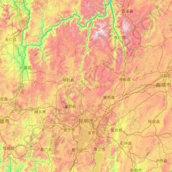
Name: Kunming topographic map, elevation, terrain.
Location: Kunming, Yunnan, China (24.38890 102.16798 26.54849 103.66897)
Average elevation: 1,996 m
Minimum elevation: 714 m
Maximum elevation: 4,151 m
Make a donation
Other topographic maps
Click on a map to view its topography, its elevation and its terrain.
Make a donation
Make a donation
Baihetan Dam
China > Yunnan > Qiaojia County > Zhaotong City > Dazhai
The Baihetan Dam (simplified Chinese: 白鹤滩大坝; traditional Chinese: 白鶴灘大壩; pinyin: Báihètān Dàbà) is a large hydroelectric dam on the Jinsha River, an upper stretch of the Yangtze River in Sichuan and Yunnan provinces, in southwest China. The dam is a 289-meter-tall double-curvature arch…
Average elevation: 1,061 m
Make a donation
Yuanyang
China > Yunnan > Yuanyang County
It covers an area of 2,200 km2 (850 sq mi) and has a population of approximately 365,000 (2002), of which 88% belong to ethnic minorities and 95% is associated with agriculture. The majority of the inhabitants of the county are from the Hani ethnic group. The GDP of Yuanyang county in 2021 was 9,312 million…
Average elevation: 1,171 m
Make a donation
Tengchong
Situated at the southwestern end of the (transversely faulted) Hengduan Mountains, Tengchong topographically assumes the form of a horseshoe with the opening facing the south. The easternmost sources of the Irrawaddy River issue from the high mountains at the summit of Mount Danaozi of Gaoligong Mountain,…
Average elevation: 1,770 m
Make a donation
Make a donation
Make a donation
Jade Dragon Snow Mountain
China > Yunnan > Lijiang City
The view of the massif from the gardens at the Black Dragon Pool (Heilong Tan) in Lijiang is noted as one of China's finest views. The mountain is part of Yulong Snow Mountain National Scenic Area and National Geological Park, an AAAAA-classified scenic area. The Park operates a tourist cable car that climbs…
Average elevation: 4,829 m
Make a donation
Zhenyuan
China > Yunnan > Zhenyuan Yi, Hani and Lahu Autonomous County > Enle
Average elevation: 1,563 m
Make a donation
Make a donation
Shilin Stone Forest Landscape District
China > Yunnan > Shilin Yi Autonomous County > Kunming
The strata are part of a gentle (2-6 degree) westward dipping monocline. Conjugate shear joints (NE-SW and NE-SE) are well developed and these fractures provided the main passageways for surface and underground water in the pre-karst development stage. The distribution, density and orientation of the fractures…
Average elevation: 1,767 m
Make a donation
Make a donation
Napahai Nature Reserve
China > Yunnan > Shangri-La > Jiantang > Chui Zongdala
Average elevation: 3,410 m
Make a donation
Make a donation
Make a donation
Make a donation
Make a donation