
Thank you for supporting this site ❤️
Make a donation
Make a donation
Ottobeuren topographic map
Click on the map to display elevation.
Thank you for supporting this site ❤️
Make a donation
Make a donation
About this map
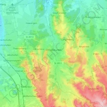
Name: Ottobeuren topographic map, elevation, terrain.
Location: Ottobeuren, Landkreis Unterallgäu, Beieren, 87724, Duitsland (47.88169 10.26544 47.99362 10.38248)
Average elevation: 684 m
Minimum elevation: 607 m
Maximum elevation: 841 m
Thank you for supporting this site ❤️
Make a donation
Make a donation
Other topographic maps
Click on a map to view its topography, its elevation and its terrain.