
Mutthorn topographic map
Interactive map
Click on the map to display elevation.
About this map
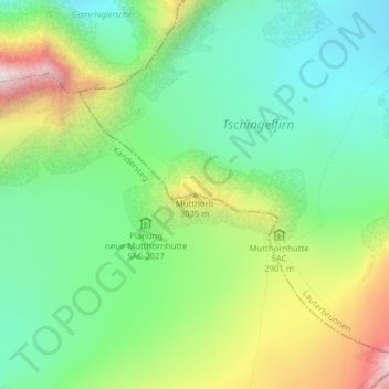
Name: Mutthorn topographic map, elevation, terrain.
Average elevation: 2,801 m
Minimum elevation: 2,513 m
Maximum elevation: 3,348 m
Other topographic maps
Click on a map to view its topography, its elevation and its terrain.
Jungfrau
Svizzera > Berna > Lauterbrunnen
Jungfrau, Lauterbrunnen, Verwaltungskreis Interlaken-Oberhasli, Verwaltungsregion Oberland, Berna, 3801, Svizzera
Average elevation: 3,401 m
Eiger
Svizzera > Berna > Lauterbrunnen
Eiger, Lauterbrunnen, Verwaltungskreis Interlaken-Oberhasli, Verwaltungsregion Oberland, Berna, 3801, Svizzera
Average elevation: 2,940 m
Rottalhorn
Svizzera > Berna > Lauterbrunnen
Rottalhorn, Lauterbrunnen, Verwaltungskreis Interlaken-Oberhasli, Verwaltungsregion Oberland, Berna, 3801, Svizzera
Average elevation: 3,406 m
Schilthorn
Svizzera > Berna > Lauterbrunnen
Schilthorn, Lauterbrunnen, Verwaltungskreis Interlaken-Oberhasli, Verwaltungsregion Oberland, Berna, Svizzera
Average elevation: 2,457 m