
Thank you for supporting this site ❤️
Make a donation
Make a donation
Taung Paw topographic map
Click on the map to display elevation.
Thank you for supporting this site ❤️
Make a donation
Make a donation
About this map
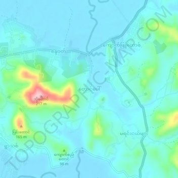
Name: Taung Paw topographic map, elevation, terrain.
Location: Taung Paw, Myeik District, Tanintharyi Region, Myanmar (12.44743 98.66354 12.48743 98.70354)
Average elevation: 32 m
Minimum elevation: 2 m
Maximum elevation: 198 m
Thank you for supporting this site ❤️
Make a donation
Make a donation
Other topographic maps
Click on a map to view its topography, its elevation and its terrain.