
Thank you for supporting this site ❤️
Make a donation
Make a donation
Moorestown Township topographic map
Click on the map to display elevation.
Thank you for supporting this site ❤️
Make a donation
Make a donation
About this map
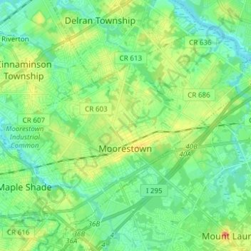
Name: Moorestown Township topographic map, elevation, terrain.
Average elevation: 15 m
Minimum elevation: 0 m
Maximum elevation: 46 m
Thank you for supporting this site ❤️
Make a donation
Make a donation
Other topographic maps
Click on a map to view its topography, its elevation and its terrain.
Crescent Heights
United States > New Jersey > Burlington County > Southampton Township
Average elevation: 17 m