
Thank you for supporting this site ❤️
Make a donation
Make a donation
Grayling Charter Township topographic map
Click on the map to display elevation.
Thank you for supporting this site ❤️
Make a donation
Make a donation
About this map
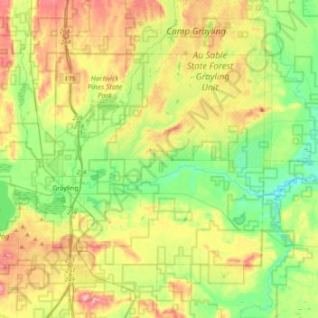
Name: Grayling Charter Township topographic map, elevation, terrain.
Average elevation: 368 m
Minimum elevation: 313 m
Maximum elevation: 453 m
Thank you for supporting this site ❤️
Make a donation
Make a donation
Other topographic maps
Click on a map to view its topography, its elevation and its terrain.
East Branch Au Sable River
United States > Michigan > Crawford County > Grayling
Average elevation: 364 m
Thank you for supporting this site ❤️
Make a donation
Make a donation