
Thank you for supporting this site ❤️
Make a donation
Make a donation
Espanola topographic map
Click on the map to display elevation.
Thank you for supporting this site ❤️
Make a donation
Make a donation
Espanola
Española lies at an elevation of around 5,595 feet (1,705 m) with much variance. It is in a valley nestled between the Jemez and Sangre de Cristo mountain ranges, and the meeting point of three rivers, the Rio Grande, the Rio Chama, and the Rio Santa Cruz.
Thank you for supporting this site ❤️
Make a donation
Make a donation
About this map
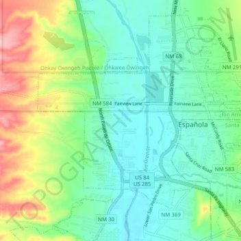
Name: Espanola topographic map, elevation, terrain.
Average elevation: 1,739 m
Minimum elevation: 1,697 m
Maximum elevation: 1,839 m
Thank you for supporting this site ❤️
Make a donation
Make a donation