
Make a donation
Jezzine topographic map
Click on the map to display elevation.
Make a donation
Jezzine
Jezzine (Arabic: جزين Jizzīn) is a town in Lebanon, located 22 km (14 mi) from Sidon and 40 km (25 mi) south of Beirut. It is the capital of Jezzine District. Surrounded by mountain peaks, pine forests (like the Bkassine Pine Forest), and at an average altitude of 950 m (3,117 ft), it is the main summer resort and tourist destination of South Lebanon. The town is also well-known in Lebanon for its production of handmade, traditional cutlery and daggers with decorative inlays, artisanal wine, and the shrine of Our Lady of the Waterfall.
Make a donation
About this map
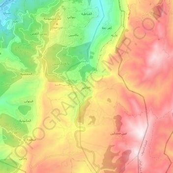
Name: Jezzine topographic map, elevation, terrain.
Location: Jezzine, Jezzine District, South Governorate, 1623, Lebanon (33.50393 35.54439 33.58393 35.62439)
Average elevation: 1,072 m
Minimum elevation: 393 m
Maximum elevation: 1,688 m
Make a donation
Other topographic maps
Click on a map to view its topography, its elevation and its terrain.
Sidon
The city of Sidon is administered by the Municipality of Sidon. The municipality is constituted of a council of 21 members including the City Mayor and his Deputy. It has administrative and financial independence but remains under the control and supervision of the central government, specifically the Ministry…
Average elevation: 38 m
Sidon
The city of Sidon is administered by the Municipality of Sidon. The municipality is constituted of a council of 21 members including the City Mayor and his Deputy. It has administrative and financial independence but remains under the control and supervision of the central government, specifically the Ministry…
Average elevation: 44 m
Make a donation
Sidon
The city of Sidon is administered by the Municipality of Sidon. The municipality is constituted of a council of 21 members including the City Mayor and his Deputy. It has administrative and financial independence but remains under the control and supervision of the central government, specifically the Ministry…
Average elevation: 38 m
Make a donation
Make a donation
Tyre
Since 2008, a Lebanese-French team under the direction by Pierre-Louis Gatier of the University of Lyon has been conducting archaeological and topographical work. When international archeological missions in Syria came to a halt after 2012 due to the war there, some of them instead started excavations in Tyre,…
Average elevation: 5 m
Make a donation
Tyre
Since 2008, a Lebanese French team under the direction by Pierre-Louis Gatier of the University of Lyon has been conducting archaeological and topographical work. When international archeological missions in Syria came to a halt after 2012 due to the war there, some of them instead started excavations in Tyre,…
Average elevation: 5 m