
Thank you for supporting this site ❤️
Make a donation
Make a donation
Blaenavon topographic map
Click on the map to display elevation.
Thank you for supporting this site ❤️
Make a donation
Make a donation
About this map
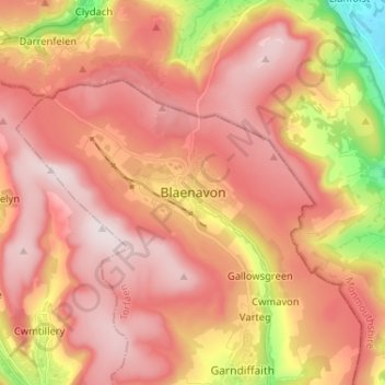
Name: Blaenavon topographic map, elevation, terrain.
Location: Blaenavon, Torfaen, Wales, NP4 9EJ, United Kingdom (51.73282 -3.12438 51.81282 -3.04438)
Average elevation: 383 m
Minimum elevation: 44 m
Maximum elevation: 575 m
Thank you for supporting this site ❤️
Make a donation
Make a donation
Other topographic maps
Click on a map to view its topography, its elevation and its terrain.
Thank you for supporting this site ❤️
Make a donation
Make a donation
Thank you for supporting this site ❤️
Make a donation
Make a donation