
Thank you for supporting this site ❤️
Make a donation
Make a donation
Newmarket topographic map
Click on the map to display elevation.
Thank you for supporting this site ❤️
Make a donation
Make a donation
Newmarket
Newmarket's geographical coordinates are 44.05°N, 79.46°W, and its elevation above sea level is 252 m. It has an area of 38.33 km2. The town is bounded on the south by Aurora, on the west by King, on the north by East Gwillimbury and on the east by Whitchurch–Stouffville.
Thank you for supporting this site ❤️
Make a donation
Make a donation
About this map
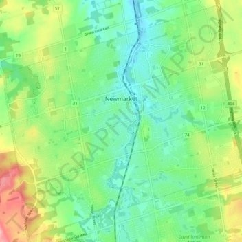
Name: Newmarket topographic map, elevation, terrain.
Average elevation: 270 m
Minimum elevation: 230 m
Maximum elevation: 349 m
Thank you for supporting this site ❤️
Make a donation
Make a donation