
Thank you for supporting this site ❤️
Make a donation
Make a donation
Kirriemuir topographic map
Click on the map to display elevation.
Thank you for supporting this site ❤️
Make a donation
Make a donation
Kirriemuir
The family estate of Sir Hugh Munro, who created Munro's Tables of Scottish mountains over 3,000 ft. in elevation (which are now called "munros"), is also located near the town.
Thank you for supporting this site ❤️
Make a donation
Make a donation
About this map
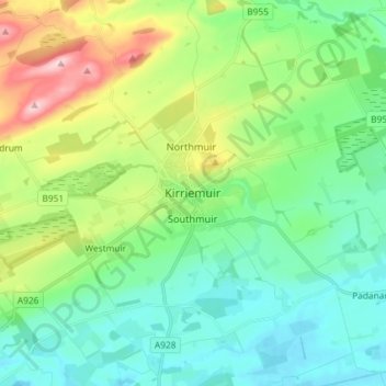
Name: Kirriemuir topographic map, elevation, terrain.
Location: Kirriemuir, Angus, Scotland, DD8 4EF, United Kingdom (56.63311 -3.04439 56.71311 -2.96439)
Average elevation: 123 m
Minimum elevation: 51 m
Maximum elevation: 312 m
Thank you for supporting this site ❤️
Make a donation
Make a donation
Other topographic maps
Click on a map to view its topography, its elevation and its terrain.
Thank you for supporting this site ❤️
Make a donation
Make a donation
Thank you for supporting this site ❤️
Make a donation
Make a donation
Thank you for supporting this site ❤️
Make a donation
Make a donation
Thank you for supporting this site ❤️
Make a donation
Make a donation