
Make a donation
Westmoreland topographic map
Click on the map to display elevation.
Make a donation
Westmoreland
According to the United States Census Bureau, the town has a total area of 36.8 square miles (95.4 km2), of which 35.8 square miles (92.7 km2) is land and 1.0 square mile (2.7 km2), or 2.80%, is water. Westmoreland is bounded on the west by the Connecticut River, which is the state border with Vermont. Hyland Hill, elevation 1,510 feet (460 m) and the highest point in town, is on the eastern border and although it is now private land, it is a local hiking and hunting destination.
Make a donation
About this map
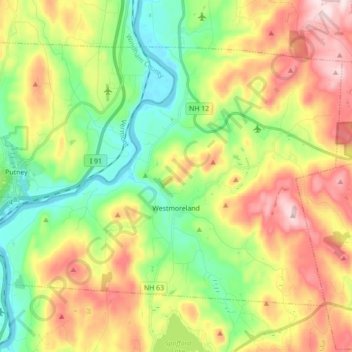
Name: Westmoreland topographic map, elevation, terrain.
Average elevation: 228 m
Minimum elevation: 62 m
Maximum elevation: 465 m
Make a donation
Other topographic maps
Click on a map to view its topography, its elevation and its terrain.
Mount Monadnock
United States > New Hampshire > Cheshire County > Jaffrey
From the base to the summit, floral species diminish with increasingly shallow soil levels. The summit is home to many different specialized sub-alpine species which can retain moisture for long periods of time. Alpine and sub-alpine species include mountain ash, cotton grass, sheep laurel, mountain sandwort,…
Average elevation: 687 m
Stone Pond
United States > New Hampshire > Cheshire County > Marlow > Gee Mill
Average elevation: 430 m
Make a donation
Camp Notre Dame
United States > New Hampshire > Cheshire County > Chesterfield
Average elevation: 223 m
Mount Monadnock
United States > New Hampshire > Cheshire County > Jaffrey
From the base to the summit, floral species diminish with increasingly shallow soil levels. The summit is home to many different specialized sub-alpine species which can retain moisture for long periods of time. Alpine and sub-alpine species include mountain ash, cotton grass, sheep laurel, mountain sandwort,…
Average elevation: 687 m
Make a donation
Mount Monadnock
United States > New Hampshire > Cheshire County > Jaffrey
From the base to the summit, floral species diminish with increasingly shallow soil levels. The summit is home to many different specialized sub-alpine species which can retain moisture for long periods of time. Alpine and sub-alpine species include mountain ash, cotton grass, sheep laurel, mountain sandwort,…
Average elevation: 687 m
Gilboa Mountain
United States > New Hampshire > Cheshire County > Westmoreland
Average elevation: 331 m
West Chesterfield
United States > New Hampshire > Cheshire County > Chesterfield
Average elevation: 168 m
Make a donation