
Fürstenau topographic map
Interactive map
Click on the map to display elevation.
About this map
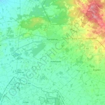
Name: Fürstenau topographic map, elevation, terrain.
Average elevation: 53 m
Minimum elevation: 26 m
Maximum elevation: 136 m
Other topographic maps
Click on a map to view its topography, its elevation and its terrain.
Bramsche
Allemagne > Basse-Saxe > Osnabrück (arrondissement)
Bramsche, Osnabrück (arrondissement), Basse-Saxe, 49565, Allemagne
Average elevation: 65 m
Fürstenau
Allemagne > Basse-Saxe > Osnabrück (arrondissement) > Fürstenau > Fürstenau
Fürstenau, Samtgemeinde Fürstenau, Osnabrück (arrondissement), Basse-Saxe, 49584, Allemagne
Average elevation: 54 m