
Thank you for supporting this site ❤️
Make a donation
Make a donation
Laa an der Thaya topographic map
Click on the map to display elevation.
Thank you for supporting this site ❤️
Make a donation
Make a donation
About this map
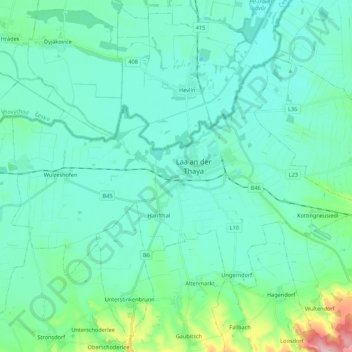
Name: Laa an der Thaya topographic map, elevation, terrain.
Average elevation: 197 m
Minimum elevation: 165 m
Maximum elevation: 352 m
Thank you for supporting this site ❤️
Make a donation
Make a donation
Other topographic maps
Click on a map to view its topography, its elevation and its terrain.
Wolfpassing an der Hochleithen
Austria > Lower Austria > Bezirk Mistelbach > Gemeinde Hochleithen
Average elevation: 241 m
Thank you for supporting this site ❤️
Make a donation
Make a donation
Michelstetten
Austria > Lower Austria > Bezirk Mistelbach > Gemeinde Asparn an der Zaya
Average elevation: 320 m
Wolkersdorf im Weinviertel
Austria > Lower Austria > Bezirk Mistelbach > Gemeinde Wolkersdorf im Weinviertel
Average elevation: 206 m