
Thank you for supporting this site ❤️
Make a donation
Make a donation
Monashee Mountains topographic map
Click on the map to display elevation.
Thank you for supporting this site ❤️
Make a donation
Make a donation
About this map
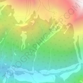
Name: Monashee Mountains topographic map, elevation, terrain.
Average elevation: 1,685 m
Minimum elevation: 1,074 m
Maximum elevation: 2,674 m
Thank you for supporting this site ❤️
Make a donation
Make a donation
Other topographic maps
Click on a map to view its topography, its elevation and its terrain.
Enderby Cliffs
Canada > British Columbia > Regional District of North Okanagan > Area F (Grindrod/Ashton Creek/Mabel Lake)
Average elevation: 911 m
Cooke Creek
Canada > British Columbia > Regional District of North Okanagan > Area F (Grindrod/Ashton Creek/Mabel Lake)
Average elevation: 838 m
Mabel Lake
Canada > British Columbia > Regional District of North Okanagan > Area F (Grindrod/Ashton Creek/Mabel Lake)
Average elevation: 1,164 m