
Thank you for supporting this site ❤️
Make a donation
Make a donation
Tiltonsville topographic map
Click on the map to display elevation.
Thank you for supporting this site ❤️
Make a donation
Make a donation
About this map
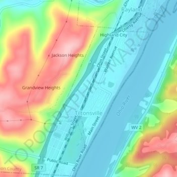
Name: Tiltonsville topographic map, elevation, terrain.
Location: Tiltonsville, Jefferson County, Ohio, 43963, United States (40.16098 -80.70622 40.17989 -80.68710)
Average elevation: 251 m
Minimum elevation: 194 m
Maximum elevation: 357 m
Thank you for supporting this site ❤️
Make a donation
Make a donation
Other topographic maps
Click on a map to view its topography, its elevation and its terrain.