
Thank you for supporting this site ❤️
Make a donation
Make a donation
Roswar topographic map
Click on the map to display elevation.
Thank you for supporting this site ❤️
Make a donation
Make a donation
About this map
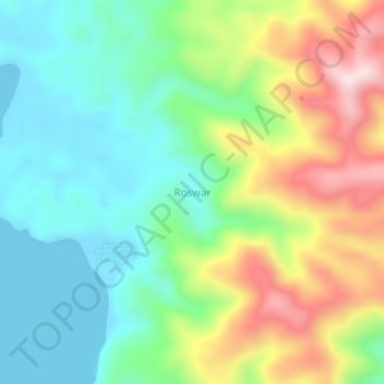
Name: Roswar topographic map, elevation, terrain.
Location: Roswar, West Papua, Western New Guinea, Indonesia (-2.12092 134.32829 -2.08092 134.36829)
Average elevation: 149 m
Minimum elevation: 0 m
Maximum elevation: 425 m
Thank you for supporting this site ❤️
Make a donation
Make a donation
Other topographic maps
Click on a map to view its topography, its elevation and its terrain.
Danau Anggi Gida
Indonesia > West Papua > Pegunungan Arfak > Krobut / Kiwot
Average elevation: 1,957 m
Thank you for supporting this site ❤️
Make a donation
Make a donation