
Thank you for supporting this site ❤️
Make a donation
Make a donation
Pallatanga topographic map
Click on the map to display elevation.
Thank you for supporting this site ❤️
Make a donation
Make a donation
About this map
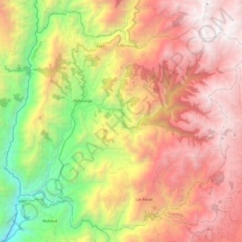
Name: Pallatanga topographic map, elevation, terrain.
Location: Pallatanga, Chimborazo, Ecuador (-2.11890 -79.03802 -1.91549 -78.81454)
Average elevation: 2,564 m
Minimum elevation: 620 m
Maximum elevation: 4,336 m
Thank you for supporting this site ❤️
Make a donation
Make a donation
Other topographic maps
Click on a map to view its topography, its elevation and its terrain.