
Igls topographic map
Interactive map
Click on the map to display elevation.
About this map
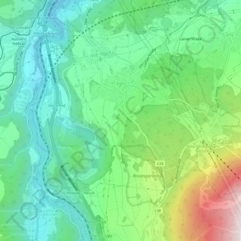
Name: Igls topographic map, elevation, terrain.
Location: Igls, Innsbruck, Tirol, 6080, Österreich (47.21077 11.39921 47.23972 11.45397)
Average elevation: 890 m
Minimum elevation: 617 m
Maximum elevation: 1,540 m
Die früher romanische Pfarrkirche ist seit 1286 aus einem Ablassbrief bekannt; im 15. Jahrhundert wurde sie im spätgotischen Stil umgebaut und 1479 geweiht. 1705 wurde sie erneut umgebaut und barockisiert. Oberhalb von Igls auf 1240 m Höhe steht die 1662 erbaute Wallfahrtskirche Heiligwasser (Maria Schnee/Hl. Ottilie). Die Wallfahrt geht auf eine Marienerscheinung zurück, der Quelle bei der kleinen Barockkirche wird heilende Wirkung zugeschrieben.
Other topographic maps
Click on a map to view its topography, its elevation and its terrain.
Innsbruck
Österreich > Tirol > Innsbruck
Innsbruck, Statutarstadt Innsbruck, Tirol, Österreich
Average elevation: 611 m